Saturday 24 April 2010

Lycia Day 5: Antiphellus, Dereaza, Sura, Demre, and Andriaca

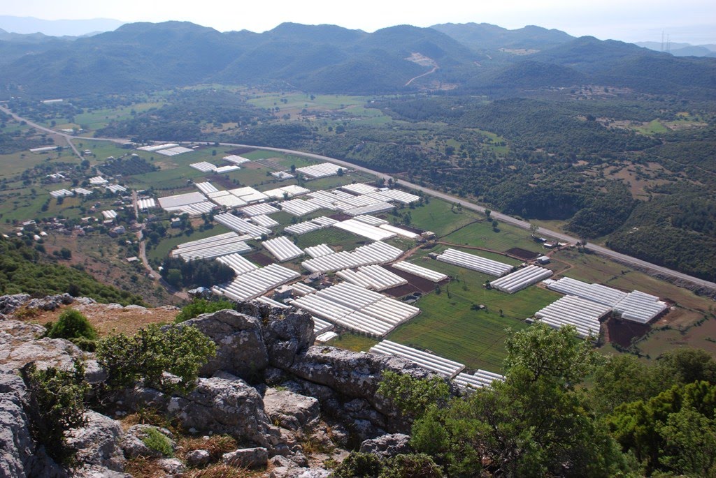
Passing swiftly over my presentation, on the Doric Tomb at Antiphellus (map), we hustled on to Dereağzı (map), where there is a fortress high on a triangular cliff overlooking the confluence of two rivers, and a Byzantine church nestling in the valley beneath.

Dereağzı church

There was also an inviting looking tell some distance away, so while the others explored the church, I hiked over and conducted an impromptu surface survey. Nothing to report, alas, but the local goats found me highly entertaining.

What is that fool doing?

Sura (map), our next site, introduced a slight variant into our standard 'get-off-the-bus-and-walk-straight-up-the-nearest-hill-through-delightfully-thorny-bushes'' routine: 'walk-downhill-through-delightfully etc'. To lull us into a false sense of security, though, we first listened toa presentation on an unusual tomb, consisting of a rock-cut tomb with a pillared sarcophagus tomb on top.

Sura necropolis

Then, though, the fun began. As if that were not enough, the church and temple we were to find were idyllically set on the valley floor, requiring some delicate footwork to hop from stone to stone, and to shimmy round their foundations. Not everyone made it unscathed.

Sura church, and hill behind

Lunch we ate in Demre (map), the modern town atop Myra (map), the home of St Nicholas, - or Santa Claus, if you prefer, - where he was bishop in the fourth century. As such, it was only right to pay our respects at the basilica where he was buried, - until his remains were removed to Bari.

St Nick

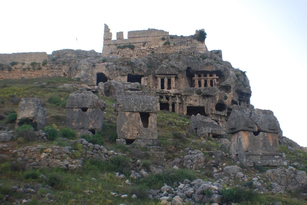
There was also a particularly finely carved tomb in the necropolis which we wanted to visit. As usual, this was one of the less accessible tombs (top left).

Myra Necropolis

Procession to the tomb

Once we were all down unscathed, and had persuaded one of the local boys he really did not want to join us for the rest of the day, we were off to our final site: Andriaca (map). Like Patara, this is a harbour site, and, like Patara, it has a fine preserved granary, in this case Hadrianic, and a mere sixty-five by thirty two metres in plan.

The granary


Why did they need to store so much grain? For import? or, surely more likely, for export, - in which case it says much about the productivity of this area in antiquity. Still more impressive to me, though, was the vaulted basement under the marketplace.

The perfect place for hide and seek


Lycia Day 4: Cyaneae, Hoydan, Trysa - and a boat-trip

We were warned that today would be the hardest day of the entire trip, - as we were to visit Cyaneae (map), and, as at Oenoanda, the only way to reach it was to abandon our bus at the bottom of the hill and climb for about an hour straight up the hill.


so glad we did not climb all the way

Fortunately, though, since the School last came, a new dirt track had been created, and the driver was amenable to taking us part of the way along. Much easier... so much so that, as a bonus, we were able to fit in an extra site, Hoyran (map, modern name, ancient unknown), where there was a particularly impressive array of tombs. The most impressive was right in the middle of the village, with a glorious frieze on the facade.


Hoyran

An entertaining consequence of all this tomb chasing was that we were overtaken by the local goat herd not once, but twice! How often does that happen...

goats overtake on the left in Turkey

After a quick lunch stop at the side of the road, we were off again to our second climb of the day: Trysa (map), the site of what was a quite spectacular heroum. No fewer than two hundred and forty metres of frieze greeted the visitor in antiquity, with a wide range of heroic feats including episodes mentioned in the Iliad and Odyssey, the deeds of Bellerophon and Theseus, battles between Greeks and Amazons ('Amazonomachies'), and between Centaurs and Lapiths ('Centauromachies'), and much more.


Disturbed peace

Some parallels are mentioned in literary sources (eg, the Throne of Apollo at Amyclae), but nothing quite so brash is known archaeologically - so far. What makes it all the more impressive is the location: the crest of a plateau about two hundred metres above the road and valley beneath.

Trysa

We were the first School group to visit, - and we may well be the last, given the time it took to hack our way through the undergrowth and up the hill, but it was very fine.

a bonus on the way down

To rest after our climb, we visited a different site, - a sunken city just off the coast. Hopping on the boat at Kaleüçağız (map), we made our way slowly along Kekova island (map), taking care not to get too close to the ruins.


Kaleüçağız harbour

To protect the ruins, boats are no longer allowed to stop on the island. Instead, we continued on to Kaleköy (map). This is a small village only accessible on foot or by boat, and the site of a crusader castle with some older remains (theatre, bouleuterium) inside. We explored for an hour or so, before a well-earned rest of the evening.


Kaleköy

Thursday 22 April 2010

Lycia Day 3: the Letoum, Xanthus, and Patara

The Letoum (map), near Xanthus, became one of the most important religious sites in Lycia in the Hellenistic period not just for the city itself, but for the whole Lycian League. As the name suggests, it was primarily dedicated to Leto, mother of Apollo and Artemis, and one version of Apollo's birth myth had him born here rather than at Delos.


The three temples of the Letoum

It is also important as the place where the Xanthus trilingual was found, the local equivalent of the Rosetta Stone. With closely related texts written in Greek, Aramaic, and Lycian, it is still crucial to the on-going cracking of Lycian. All this, however, was of no interest to the only other occupants of the site, who were much more interested in the limestone-lined swimming pool created by the current flooding of the site.


The formation swimming team during practice

Only about five kilometres away lie the remains of Xanthus (map) itself. This is famous as the home of some of the British Museum's most prized treasures, including the Harpy and Nereid monuments. Though rather forlorn without their sculpture, they were still commanding in their position overlooking one of the main roads into the city.


The Nereid monument sans sculpture (see BM website)

Rather less portable were the remains of the ancient theatre. This particular theatre seems unusual for this region, as the first we have seen which was converted by the Romans for gladiatorial and wild-animal hunts. Though this is common elsewhere (eg, Ionia), it is not here for reasons not entirely clear to me; arguing from the size of the city alone simply does not seem sufficient as an explanans.


Note the original seat line

Our final site was Patara (map), perhaps the largest seaport in Lycia, As such, it boasts what some claim to be the world's oldest lighthouse remains, from c AD 60.


It was presumably just a tad taller in antiquity

Another unusual building is a very fine monumental arch honouring Mettius Modestus, governor of Lycia between c AD 99 and AD 102. This is distinctive just in its location (perhaps the only such in Lycia?), but in not honouring/being vowed by an emperor (again, perhaps the only such?).


The arch cunningly also formed part of the aqueduct

Being on the sea, however, the site exploration would not have been complete without a visit to the beach, - and I am pleased to be able to report that the Mediterranean is just a tad warmer than it was in Selinunte exactly a month ago!


Nothing but sea, sky, - and a group from the American School


Just minding my own business

Wednesday 21 April 2010

Lycia Day 2: Oenoanda, Pinara, Sidyma

Today was a day of extremes: in the first two hours on site, we had blazing sun, torrential rain, and hail! Luckily, the rain only started in earnest on our way back to the bus, but it was still a long forty-five minute hike down the hill from our first site, Oenoanda (map), a mere 1430m above sea level, to where we had abandoned the bus.


Fortunately, it did not snow on us...

Oenoanda is famous in large part for its epigraphical remains, which include a very long text by Diogenes, an epicurean philosopher, of which 6000 of perhaps an original 25000 words remain, and an inscription establishing a festival in AD 124 which is important for our understanding of Roman provincial administration. The fortification wall and aqueduct, though, are equally as impressive.


Oenoanda tower

We were, moreover, rather traumatised by Oenoanda: no Lycian tomb?! Impossible. The second site, Pinara (map), fortunately restored our faith.


Bird-nests?

Yes, those are tombs. No, we did not explore them. Looking at them, I wonder how mad Pliny the Younger's suggestion that their inhabitants were bird-men really was. We did, though, climb down a ravine to find some with some unusual, - and very worn, - city reliefs, and admire the theatre.


From the 60s?


Did spectators pay extra for shadow?

At our final site, Sidyma (map), the main attraction was the array of tombs, in particular one with some unique coffering.


The coffering

To keep us company, we had a special, very curious, and hyper-energetic guest.


Jump? or not? Jump? or not? Jump!

As wonderfully often so far this trip, we were also offered tea by the local guide, - and so could admire the speed with which people nearby were weaving.


The loom


Tuesday 20 April 2010

Lycia day 1: Caunus, Cadyanda, and Tlos

Today we visited three wonderful and very different sites, Caunus (map), Cadyanda (map), and Tlos (map), as we slowly made our way from Marmaris (map) to Fethiye (map). To help us navigate the sometimes narrow and winding roads up to the sites, we have a tiny bus packed to the rafters.


breathe in...

Caunus, though, our first destination, required a boat ride.


Peak season?

The ride was all the more special for the procession of Lycian rock-cut tombs we passed as we put-putted along the river.


Not a bad view...

Impressive though they look, they were all robbed long ago, - as nearly all of them have always been visible, - so we did not stop at these. We will be visiting more than enough these next few days...! Besides the tombs, Caunus also boasts a significant population of tortoises.


You are in my sun!

In case you are wondering what a Lycian tomb looks like, herewith a fine example of a rock-cut version from Cadyanda.


exhibit no 1

They come in many shapes and sizes, and date from throughout classical antiquity. They are also often quite finely carved, as on the side of this second Cadyandan tomb.


exhibit no 2

Alas, though, they were often carved out of soft local stone, and so have suffered very badly from weathering. Or worse:


exhibit no 3

There is also one significant difference in practice from contemporary practice on the Greek mainland. There, the custom was to bury the dead outside the city limits, often along the main roads. Here, though...


Tomb cluster on Tlos acropolis, with Ottoman fortress above

One advantage of clambering round to reach the tombs was that we did have a chance to enjoy the sites in their entirety.


Spring arriving at Tlos

But fear not! We did not spend the entire day just looking at tombs. Other highlights included three very fine theatres; two stadia (not Caunus) and basilicas (not Cadyanda); and no fewer than three round structures at Caunus. These last in particular made some of us (who had perhaps better remain nameless) very excited.


Tlos theatre arch detail


Tlos agora with stadium, and 'hall' behind


Note the column drums reused in the retaining wall


Monday 19 April 2010

Lycia

After a wonderful few weeks in the Balkans, I am now on my way to Lycia to join the American School for our final trip of the year, - but want to thank the American Research Centre in Sofia once again for its support, and to spurring me to visit. It has been quite wonderful, and I have lots on which to muse, as well as the sounds of a very fine Bulgarian folk music concert ringing in my ear I attended my final day. It will remain with me for quite some time, and not just because it lasted over three hours, without an interval.

Rather than return to Athens, I decided to take a Istanbul and spent a few days reacquainting myself with the city and its museums. Having already spent more hours than I care to think in the Archaeology Museum(s), I intended just a brisk walk through before moving on to more contemporary pleasures. Three hours later...


Glazed brick lions,'procession street' towards Ishtar Gate, Babylon (6th BC)


Look familiar? 'Sea God' from Nicomedia/Izmit (2nd AD)


Mediaeval marble triple capital, Dayr Latrun, NW of Jerusalem

I also finally made it to the Dolmabahçe Palace, the earliest 'European'-style palace built in Istanbul between 1843 and 1856 by Sultan Abdülmecid I, and the place where Atatürk died on 10th November, 1938. Until recently, all the clocks in the palace were set to 0905, the hour he died. It is also the home of what is claimed to be the world's largest Bohemian crystal chandelier in the world, with a mere seven hundred and fifty lamps and a weight of but four and a half tonnes. I had visions of some poor servant spending hours trying to light all the candles but it was, alas, apparently gas-lit from the start.


Dolmabahçe Palace


Changing of the Guard

The other reason for stopping in Istanbul is that I had to go to the British Consulate-General to sort out some documentation. It is worth while passing by anyway, as it is a fine 1845 neo-renaissance palazzo built from plans modified from an original design by Sir Charles Barry, who was also responsible for the Houses of Parliament. In this case, though, I mention this rather mundane event just to note how impressed (amazed?) I was with how both the Consulate-General staff and the tourists there were dealing with deal old Eyjafjallajökull. The gentleman behind the desk in the Consular Section was positively unflappable. I was, though, rather relieved to be travelling on south, not north!